From Červenohorské sedlo to Švýcárna
Červenohorské sedlo – shelter Klínovec – Malý Jezerník – Švýcárna – and back to Červenohorské sedlo
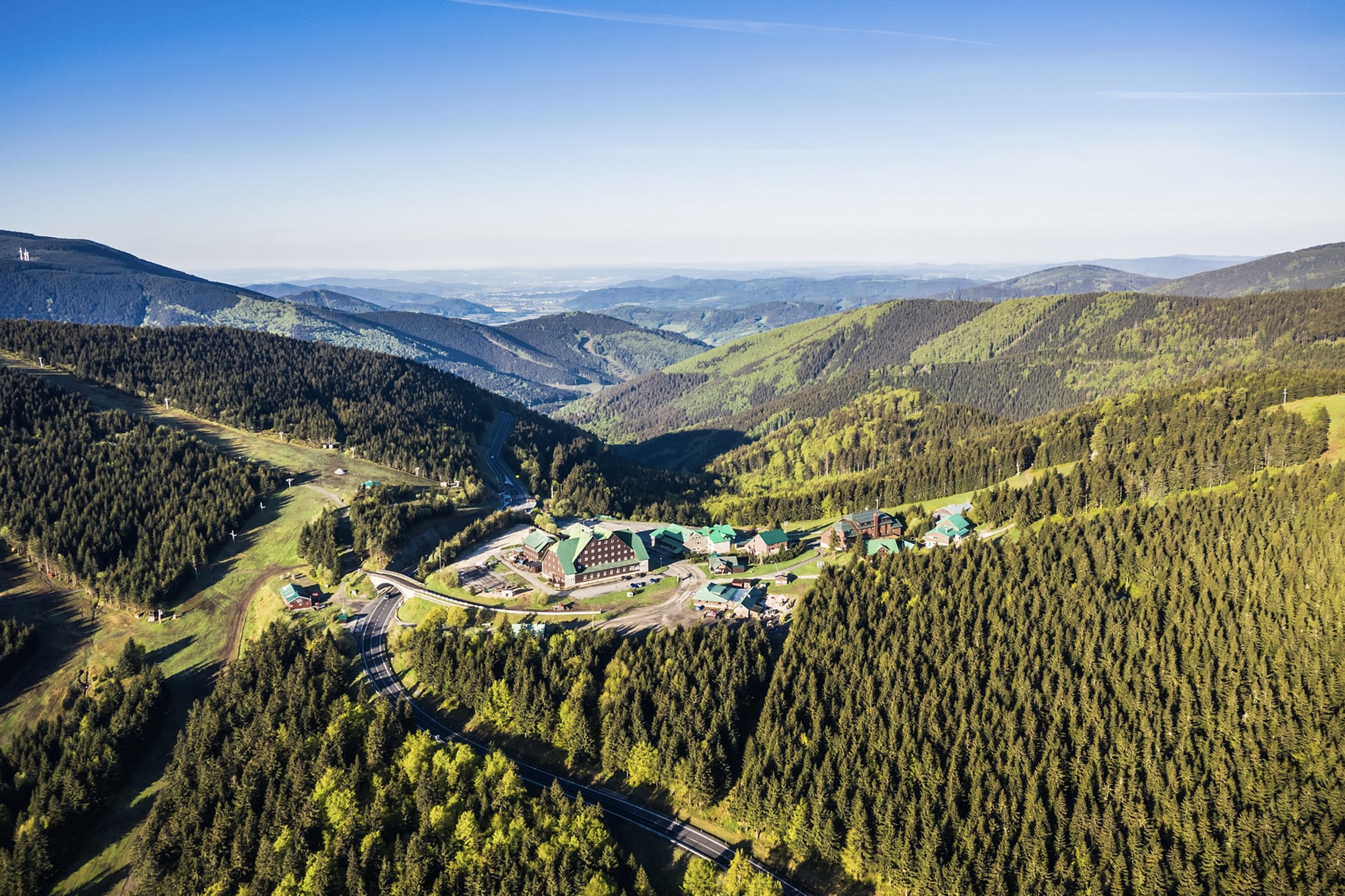
The Švýcárna tourist cottage is located on the busiest part of the Jeseníky ridge route, between the Červenohorský saddle and the highest mountain of Moravia - Praděd at an altitude of 1304 m above sea level. The main ridge trail (red trail) leads from Červenohorské sedlo past Švýcárna to Praděd, to Ovčárna and then to the Alfrédce cottage at the southern end of Hrubý Jeseník or from Barborka to Karlova Studánka. The blue trail then follows the valley of Kamenac through Vysoký vodopád to Bělá. The yellow trail leads through the Videlské sedlo past Orlík and Kazatelen to the famous Rejvíz guesthouse. In the opposite direction, the green trail descends to Kouty nad Desnou.
DESCRIPTION OF THE ROUTE (on foot)
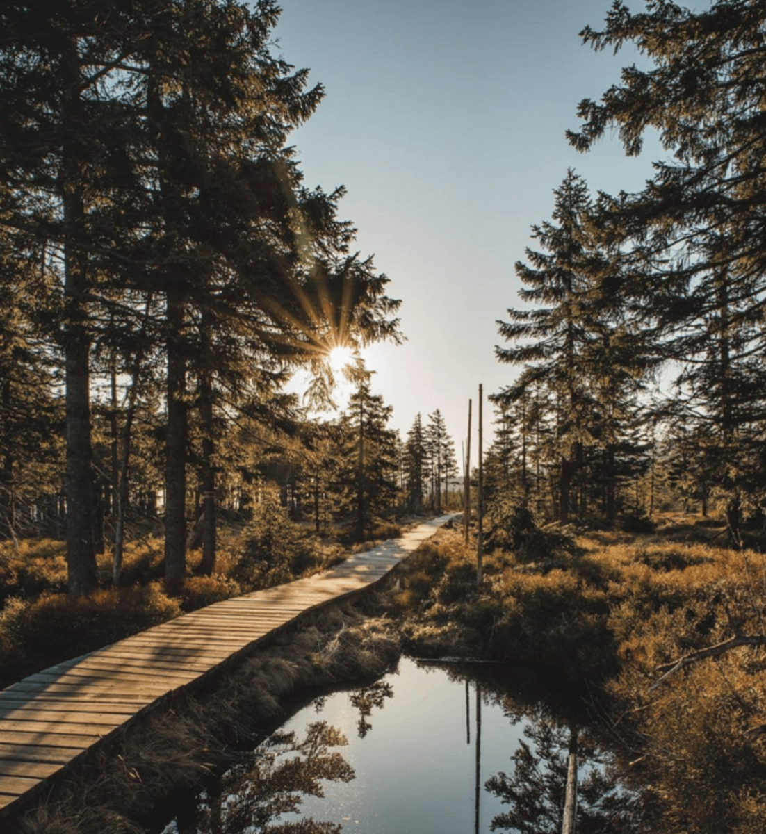
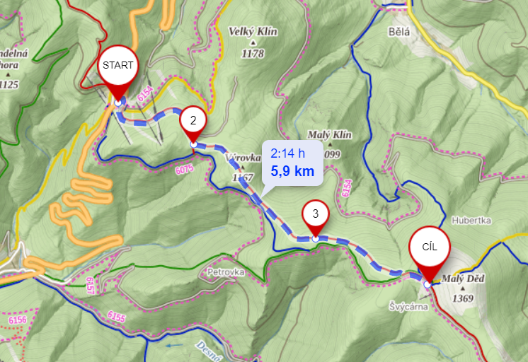
We arrive at the saddle by car and park in a large free parking lot.You can also come here by bus, the bus stop is nearby.We cross the road to the other side and join the red hiking trail here, going uphill past the ski lifts and past several ski slopes.We continue into the woods, the path is loose gravel, but after about half an hour we change to a forest track.We reach the Klínovec shelter, where there is also a lookout point. We continue on through the forest. After another half an hour we come to the crossroads Pod Malým Jezerníkem. Here the climb up the hill begins. Its ascent offers us a beautiful view of the peaks - Vozka, Červená hora and Keprník. We continue on to the Malý Jezerník hill, where the peat bog begins and the path leads along wooden paths. The path is already easy. Then we climb the last more difficult climb and finally we have won - after about half an hour we arrive at our destination. More experienced hikers can walk up to Praděd, the Peter's Stones, or perhaps climb another ridge.
DESCRIPTION OF THE ROUTE (on cross-country skis)
The popular route leads from Červenohorské sedlo via the Švýcárna chalet to the top of Praděd. Basically the whole route is uphill. From the saddle there is a short climb to Klínovec and Výrovka. The section in the area of Malý and Velký Jezerník (1304 m above sea level) has flat parts and frequent climbs. The ridge trail ends in a meadow near the Švýcárna mountain hut.
From the Červenohorské sedlo there is another more comfortable variant of the route - to the right of the ridge along a wide blue trail to the crossroads above Petrovka, from there to the left along the green trail, with a somewhat steeper climb only in a short section below Malý Jezerník. From Švýcárna you can see the panorama of the highest mountain in Moravia - Praděd. From Švýcarna it is a short, pleasant, gentle climb to Praděd. The route from Červenohorské sedlo to Praděd is 8.5 km long and is part of the Jesenická magistrála stretching across the entire ridge of the Hrubý Jeseník Mountains.
DISTANCE
12 km (there and back)
TRIP TIME
3-5 hours (there and back)
DIFFICULTY
medium
SUITABLE FOR CHILDREN
yes
SUITABLE FOR STROLLERS
no
GPS COORDINATES
50.101678, 17.213999